
Investigating the Changes of Dissolved Substances in Water Using Remote Sensing (Case Study: Al-Gharraf River)
DOI:
https://doi.org/10.51173/jt.v7i1.2625Keywords:
Remote Sensing, Water Quality Monitoring, Al-Gharraf River, Satellite Image Classification, Water Dissolved Substances ChangesAbstract
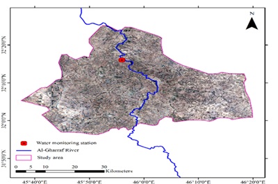
Water quality monitoring is important for water resource management, but traditional methods are expensive and limited. Remote sensing provides a practical solution to access accurate information at the lowest cost and in the fastest time. The research aims to study the changes in dissolved materials in the water of the Al-Gharraf River, which is located in the Al-Hay area in Wasit Governorate and is considered one of the main sources of surface water in Iraq. Seasonal data (winter and summer of 2021 and 2022) of water quality parameters collected from the water quality monitoring station in the study area were taken as field observations, and Landsat 8 images formed the remote sensing data for the research. Landsat images were processed using the maximum likelihood classification (MLC) algorithm and water bodies in the area were identified. The performance of MLC was evaluated with precision and precision criteria. The average classification accuracy for the train data was 0.954 and 0.970, and for the test data, they were 0.936 and 0.97, respectively. To detect water bodies, the correlation between six spectral bands, two spectral indices, and 12 different combinations of spectral bands and water quality parameters was calculated using Pearson's coefficient. The results were different depending on the qualitative criteria, but the observed high correlation coefficients showed that the remote sensing data used in the research were useful for monitoring changes in dissolved materials in the water of the Garraf River. The spatial trend of changes was analyzed by the Mann-Kendall test and the temporal trend was analyzed by fifth-order polynomial fitting. The study revealed uniform spatial and seasonal changes in river water quality standards, which affect the environment, aquatic life, and citizens. Landsat satellite data provide valuable information to monitor these changes and help decision makers manage water resources effectively.
Downloads
References
M. Gholizadeh, A. Melesse, L. Reddi, “A comprehensive review of water quality parameter estimation using remote sensing techniques,” Journal in Sensors, Aug,2016, https://doi.org/10.3390/s16081298.
E. T. Engman, R. J. Gurney, Chapman and Hall, “Remote sensing in hydrology,” International Journal of Remote Sensing”,0-412-24450-0. pp:1368, Nov,1991, https://doi.org/10.1080/01431169108955273
A. Dekker, N. Zamurović, Ž., Hoogenboom, H., & Peters, S. “Remote sensing, ecological water quality modelling and in situ measurements: a case study in shallow lakes”. Hydrological Sciences Journal,Vol.41,No.4,pp:.531-547,1996. https://doi.org/10.1080/02626669609491524
W. Duan., He, B., Takara, K., Luo, P., Nover, D., Sahu, N., & Yamashiki, Y. (2013).” Spatio-temporal assessment of water quality incidents in Japan between 1996 and 2007”. Journal in chemosphere, Vol.93, No 6, pp: 946-953, oct,2013 https://doi.org/10.1016/j.chemosphere.2013.05.060
S. Ewad, “Concentration of some Heavy Elements in Water. Sediment and Plants in Al-Gharraf River in Thi-Qar Province –South of Iraq”. Journal in University of Thi-Qar, 11, Dec, 2020. https://doi.org/10.32792/utq/utjsci/v7i2.716.
S. Ewad, “Water quality assessment of the Gharraf River using two water quality indices” Applied Water Sciences”. Iraqi Journal of Science, Vol. 57, No.2A, pp: 878-885,2016. https://doi.org/10.1007/s13201-016-0523-z
M. Bonansea., A. Melesma, and L. Reddi.” Using of new remote sensing satellites to assess reservoir water quality”. Hydrological Sciences Journal, Vol. 64 No.1, pp:.34-44. published 2 Jan,2019 https://doi.org/10.1080/02626667.2018.1552001
T. Lillesand, Kiefer, R. W., &J. Chipman, . “Remote Sensing and Image Interpretation”. John Wiley & Sons. Journal Articel published 1 August 2015 in Photogrammetric Engineering. https://doi.org/10.14358/pers.81.8.615
S. Ewad, and S. Abed. “Water Quality Index of Al-Gharraf River, Southern Iraq”. Egyptian Journal of Aquatic Research, Vol.43 No2 ,pp: 117-122, published June 2017https://doi.org/10.1016/j.ejar.2017.03.001
S. Pandey.” Water pollution and Man's health”. Kathmandu University medical journal (KUMJ), 4(1), pp:128-134, 2006, https://doi.org/10.5580/835.
M Bonansea, A. Melesma, and L. Reddi. “Using new remote sensing satellites for assessing water quality in a reservoir”. Hydrological Sciences Journal, 2, Janu, 2019. https://doi.org/10.1080/02626667.2018.1552001
L. Olmanson, P. Brezonik , &M. Bauer. “Remote sensing for regional lake water quality assessment: capabilities and limitations of current and upcoming satellite systems”. Book chapter, published in the Handbook of Environmental Chemistry. In Advances in watershed science and assessment (pp. 111-140), Springer,2015. https://doi.org/10.1007/978-3-319-14212-8_5.
S. Ewaid, S. Abed. “Water quality index for Al-Gharraf river, southern Iraq”. The Egyptian Journal of Aquatic Research, 43(2), No.117-122. published June 2017 https://doi.org/10.1016/j.ejar.2017.03.001.
S. Taimi, Kalanga, H. Zvikomborero.” Remote-sensing-based algorithms for water quality monitoring in olushanandja Dam, north -central Namibia”. Issue:5, vol:21, pp:1878-1894, Aug,2021. https://doi.org/10.2166/ws.2020.290
R D Jackson.” Spectral indices in n-space”. Journal Article published Nov, 1983, in Remote Sensing of Environment, 13(5), 409-421. https://doi.org/10.1016/0034-4257(83)90010-x.
P. Macarof, F. Statescu,” Comparison of NDBI and NDVI as indicators of surface urban heat island effect in Landsat 8 imagery :A case study of Iasi”. PESD, VOL. 11, no. 2, 2017. DOI 10.1515/pesd-2017-0032
N. Pettorelli. “The Normalized Difference Vegetation Index”. Monograph published, 10, Oct, 2013, https://doi.org/10.1093/acprof:osobl/9780199693160.001.0001.
B. C Gao.” Normalized water difference index for remote sensing of plant liquid water from space. Remote Sensing of Environment”. Journal Article published, Dec, 1996 in Remote Sensing of Environment https://doi.org/10.1016/s0034-4257(96)00067-3
C. T Nguyen, A. Chidthaisong, P. K. Diem, & L.Huo, L. “A modified bare soil index to identify bare land features during agricultural fallow-period in southeast Asia using Landsat 8”. Land, 10(3), 231. Journal Article, 25, Feb., 2021. in Land. https://doi.org/10.3390/land10030231.
A. Malek, A. Chapok, M. Sultan, B. Hashim. H. Hussain and N. Al-Ansari. “Estimation of total dissolved solids in water bodies by spectral indicators: A case study”. Journal Article September 2020 in Water, Air, & Soil Pollution https://doi.org/10.1007/s11270-020-04844-z.
A. Ahmad, & S. Quegan, S.” Analysis of Maximum Likelihood Classification Technique on Landsat 5 TM Satellite Data of Tropical Land Covers”. November 2012 in 2012 IEEE International Conference on Control System, Computing and Engineering. https://doi.org/10.1109/iccsce.2012.6487156.
T. Lillesand, R. W. Kiefer, & J. Chipman. “Remote Sensing and Image Interpretation”. John Wiley & Sons. Journal Article published 1 August 2015 in Photogrammetric Engineering. https://doi.org/10.14358/pers.81.8.615.
A. F. Militino, M. Ugarte, and U. Pérez-Gioia. “An introduction to the spatiotemporal analysis of satellite remote sensing data for geostatisticians”. In Handbook of Mathematical Geosciences (pp. 239–253).2018. https://doi.org/10.1007/978-3-319-78999-6_13.
S. Gog, and M. Dixit, M. “Conference on Advances in Signal Processing (CASP)”, Publisher, IEEE, Jun, 2016; ISBN, 1509008497, 9781509008490. https://doi.org/10.1109/casp38054.2016.
L. Hwang, and Ni, L. “Object-oriented classification of high-resolution satellite images for improved accuracy”. Spatial Resolution Assessment in Natural Resources and Environmental Sciences, IEEE, June 25-27, 2008. https://doi.org/10.1109/igarss.2008.4779519
R.Goldblatt, , Yu, W, J .Hanson ., and A.K. Khandwal . “Detecting urban boundaries in India: A dataset for pixel-based image classification in Google Earth Engine”. Journal Article, 1, Aug, 2016. in Remote Sensing Remote Sensing, 8(8), 634. https://doi.org/10.3390/rs8080634
M. Ansari, J. Nouri, and S. Fotohi, “Investigation of Temperature Precipitation and Flow Trend Using Nonparametric Man Kendall (Case Study: Kaju River in Sistan and Baluchistan)”. Journal watershed management research February 7(14):158-152,2017. https://doi.org/10.29252/jwmr.7.14.158.
R. Goldblatt, Yu, W., J.Hanson, and A. Khandiwal. “Detecting urban boundaries in India: A dataset for pixel-based image classification in Google Earth Engine”. Journal Article 1 August 2016 in Remote Sensing Remote Sensing, 8(8), 634. https://doi.org/10.3390/rs8080634
A. Maleki, A. Chapok., M.A.Sultan, B.M Hashim, H. M. Hussain, and N. Al-Ansari. “Estimation of total dissolved solids in water bodies by spectral indices case study: shatt al-Arab River”. Journal September 2020 in Water, Air, & Soil Pollution. https://doi.org/10.1007/s11270-020-04844-z.
S. A.Salman, S. Shahid, T. Ismail, K. Ahmed, E. S. Chung, and X. J.Wang. “Characteristics of annual and seasonal trends of precipitation and temperature in Iraq”. Asia-Pacific Journal of Atmospheric Sciences, Aug, 55, 429-438, 2019. https://doi.org/10.1007/s13143-018-0073-4.
W. Duan, K. Takara, He, B., Lu, P, D. Nofer, and Y. Yamashiki, “Spatial and temporal trends in estimates of nutrient and suspended sediment loads in the Ishikari River, Japan, from 1985 to 2010”, Journal in Science of the Total Environment, sept, 2013. https://doi.org/10.1016/j.scitotenv.2013.05.022.
Downloads
Published
How to Cite
Issue
Section
License
Copyright (c) 2025 Salwa Mohammed Hasan Abbas, Amir Shahrokh Amini

This work is licensed under a Creative Commons Attribution 4.0 International License.