
Identify the Optimal Path for Evacuating the Building's Occupants by Integrating GIS And BIM Technologies
DOI:
https://doi.org/10.51173/jt.v7i3.2723Keywords:
Building Information Modeling (BIM), Geographical Information System (GIS), Evacuation, Point of Assembly, EmergencyAbstract
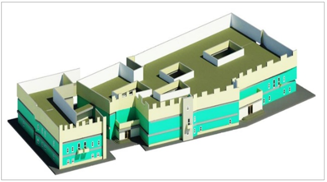
Technologies such as Geographic Information Systems (GIS) and Building Information Modeling (BIM) have evolved into complementary instruments to increase the efficacy and safety of building evacuation planning. Although geospatial analysis is provided by GIS for determining safe places of assembly and simulating evacuation pathways, BIM technology makes it feasible to perform sophisticated 3D modeling. To maximize the effectiveness of fire evacuation protocols, this study produces a three-dimensional geographical model by integrating GIS and BIM. To locate the best places to congregate outside the building that are safe, reachable, and far from potential risks, access and distance criteria were assessed using ArcGIS Pro. The effectiveness of the recommended approach is illustrated through a case study of a two-story dorm building at the University of Diyala. Results show that using ArcGIS Pro's Model Builder enhances evacuation planning by finding locations that adhere to safety and standards for accessibility and cutting down on the time and distance to assembly points. This integration provides a reliable method to improve Plans for emergency evacuation and protect building occupants.
Downloads
References
R. S. Rich and K. H. Davis, Geographic Information Systems (GIS) for Facility Management. IFMA Foundation, 2010.
Y. Cao and F. Lu, Three-Dimensional Modeling for Buildings Evacuation Management. University of Gävle, 2012.
D. F. Salman, W. A. Hatem, and N. Kadhim, “Modeling of emergency evacuation in campus buildings by integration BIM and GIS,” AIP Conference Proceedings, vol. 3105, no. 1, AIP Publishing LLC, 2024, doi: 10.1063/5.0212854.
M. Gheisari and J. Y. Ruwanpura, “Three-dimensional BIM-based fire evacuation simulations for high-rise buildings,” Automation in Construction, vol. 93, pp. 205–215, 2018. doi: 10.1016/j.autcon.2018.05.012.
A. Vanclooster, P. Maeyer, V. Fack, and N. Van de Weghe, “Calculating Least Risk Paths in 3D Indoor Space,” in Innovations in 3D Geo-Information Sciences, U. Isikdag, Ed. Cham, Switzerland: Springer International Publishing, 2014, pp. 13–31, doi: 10.1007/978-3-319-00515-7_2.
M. Duckham and L. Kulik, “‘Simplest’ paths: Automated route selection for navigation,” in Spatial Information Theory, Foundations of Geographic Information Science, W. Kuhn, M. Worboys, and S. Timpf, Eds. Berlin, Germany: Springer, 2003, pp. 169–185.
BuildingSmart, Building Smart, 2008. [Online]. Available: http://www.buildingsmarttech.org/specifications
M. P. Kwan and J. Lee, “Emergency response after 9/11: The potential of real-time 3D GIS for quick emergency response in micro-spatial environments,” Computers, Environment and Urban Systems, vol. 29, pp. 93–113, 2005.
F. F. Taha, Achieving Net-Zero Energy in Educational Buildings Using BIM, University of Diyala – College of Engineering, 2020.
B. Wu and S. Zhang, “Integration of GIS and BIM for indoor geovisual analytics,” International Archives of the Photogrammetry, Remote Sensing and Spatial Information Sciences, pp. 455–458, 2016.
“Fire safety in the workplace: Assembly points and evacuation planning.” [Online]. Available: https://www.hse.gov.uk.
L.-C. Chen, C.-H. Wu, T.-S. Shen, and C.-C. Chou, “The application of geometric network models and building information models in geospatial environments for fire-fighting simulations,” Computers, Environment and Urban Systems, no. 45, pp. 1–12, 2014.
H. R. Abed, W. A. Hatem, and N. A. Jasim, “Role of BIM technology in enhancing safety analysis of Iraqi oil projects,” Asian Journal of Civil Engineering, pp. 1–12, 2020.
N. Kadhim, “BIM and GIS Data Integration for the Evaluation of Building Performance,” The International Archives of Photogrammetry, Remote Sensing and Spatial Information Sciences, no. 46, pp. 135–139, 2022.
“Fire safety in the workplace: Assembly points and evacuation planning”, [Online]. Available: https://www.hse.gov.uk.
Downloads
Published
How to Cite
Issue
Section
License
Copyright (c) 2025 Diana Faris Salman, Wadhah A. Hatem, Nada Kadhim, Nuha A. Hussein

This work is licensed under a Creative Commons Attribution 4.0 International License.